This post may contain affiliate links. Opinions shared are my own and I only endorse products I support. By clicking on any of the links below, I may get a small commission if you make a purchase at absolutely no additional charge to you. I appreciate your support.
My family and I love to explore Point Lobos State Natural Reserve. It’s only 40 minutes away and we visit often. The trails there are amazing – they’ll take your breath away!
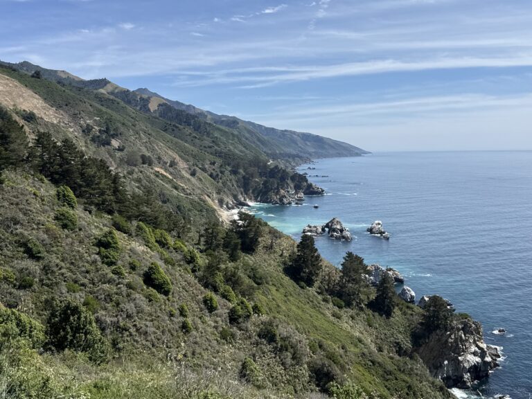
If you’re someone who appreciates nature’s finest masterpieces and enjoys exploring the great outdoors, then you’ve come to the perfect place. Point Lobos From meandering coastal pathways adorned with vibrant wildflowers to rugged cliff side routes boasting panoramic ocean views.
The Called the “Crown Jewel of California State Park System” is Located at the north end of the famous Big Sur and just few miles from Carmel by the sea. It is a Protected habitat due to its rich marine diversity and gorgeous beaches where recreational a commercial finish is restricted!
It is so big that at some point it almost became a site. Luckily it didn’t happen and instead became a Natural reserve in 1960. This is the place where the Native American Ohlone people harvest fish and live per thousands of years before becoming a shore whaling station. In addition, the sea near Point Lobos is considered one of the best locations for scuba diving on the Monterey Peninsula and along the California coast you can do this at Whalers Cove and Bluefish Cove.
Best time to visit Point Lobos
With its majestic cliffs, pristine beaches, and diverse wildlife, this enchanting coastal gem offers an unforgettable experience all year round. During, springtime From March to May, you find vibrant wildflowers carpet the landscape with their radiant colors and sweet fragrances.
Truly a magical season! Also migrating gray whales can be spotted offshore—nature’s way of saying “welcome back!” Seize this opportunity for stunning hikes along blooming trails. During Summer the ocean breezes keep things cool and comfortable. June through August is ideal for those seeking sun-soaked adventures like kayaking or snorkeling around hidden coves teeming with marine life. Plus, don’t miss the enchanting sight of playful harbor seals lazing about on rocky outcrops while seabird colonies provide a lively backdrop.
In fall is peaceful as summer crowds fade away tranquility settles from September to November. We love visiting in Fall, when the summer heat is easing, and the coast is less foggy. But the area is beautiful year-round!
How To Get To Point Lobos from Carmel or Monterey
If you’re staying in Monterey or Carmel, the park is just this spot is super close to visit! From Carmel you can head south on Highway 1 towards Big Sur. After approximately three miles (4.8 km), keep an eye out for signs directing you to turn left onto Rio Road. Continue along Rio Road until you spot the entrance sign welcoming you to Point Lobos State Natural Reserve.
Point Lobos’ Trails Map
In the map you can see the many trails Point Lobos offers. If you’re in the mood for a leisurely outdoor adventure that immerses you in breathtaking coastal landscapes, look no further than Point Lobos State Natural Reserve. Lace up your shoes, grab some snacks, and let’s delve into the beauty of this natural haven together!


Best Trails from The North Side
Whalers Cabin Trail and Museum
Coming from Monterey/Carmel this will be your first stop in the Norther part. This is one of the first ones we ever did. First, we visited the amazing museum close to the parking lot at the end close to Cannery point. Make sure you look of Cannery Point one of the few areas on the park where diving is permitted. At the museum you will immerse in the history of this park and learn about their first habitants and the whale.

A short walk from the parking lot leads you to the Whales cabin Museum. You will find volunteers explaining the history of these place and there is so much to see! Here we found whales bones and kids and us where fascinated with them! It shouldn’t take you to long to get there. It is a small building, built by Chinese fisherman around 1850. At the museum you find all the tools they used to defeat the giants of the ocean during annual immigration.
This continuously busy area was the site of a whaling station from 1862 to 1879. Where visitors now park, an abalone cannery once operated, and traces remain of a granite quarry, said to have supplied the stone for the San Francisco Mint.

On the west side of the Whalers Cabin is the Cabin Trail it starts behind Whalers Cabin. This short walk up the hill through the coastal scrub community and the Bluefish Cove (another diving by permit area) takes you to the North Shore Trail.

The North Shore Trail
🥾0.75 miles (1.2 km)
📍How to get there: You can get here following the Cabin trail or from the Sea Lion parking lot (located more south)
📷Viewpoints here: Bluefish Coves scenic view, Guillermot Island, Big Dome, Cypress Cove, and Old veteran
This is a gorgeous walk-through pine forest with open view of coves surrounded. North Shore Trail: For those seeking stunning ocean views without breaking a sweat too much (we’ve all been there!), North Shore Trail presents an ideal option. Meandering atop cliffs overlooking sea caves carved by centuries of erosion, this easy route treats hikers to panoramic views.

The trail is 0.75 but connected to the Cabin trail that leads to the Whalers Cove. The total distance between whaler’s cove and sea lion point parking area is 1.4 miles. You wont regret doing views, sea creatures and more but the trail is rocky ground and there are tree roots and some stairs to take to check the best views and points.
Granite Point Trail
🥾1 mile (1.6 km)
📍How to get there: Starts across whale cabin and goes along beautiful breathtaking Whaler’s cove.
📷Viewpoints here: Whaler’s cove, Coal Chute Point, Granite Point
♿️It is accessible.
The trail winds through dense forests, showcasing nature at its finest. At the eastern end, in Cannery Point you can take in the stunning views of Carmel Bay and Whalers Cove. During the spring and summer months, you can observe the nesting of western gulls and pigeon guillemots – a fascinating wildlife experience! Keep your eyes peeled for wildlife sightings along the way! From playful squirrels scurrying among branches to colorful birds flitting about, there’s never a dull moment as Mother Nature unveils her captivating creations.
Cypress Grove Trail:
🥾This 0.8 mile (1.3 km)
📍How to get there: Sea Lion Point Trail Parking
📷Viewpoints: North Point, The Pinnacle, Pinnacle cove , Allan memorial Grove, South Pint and on the left Headland Cove

We explore the trail’s winding path along the coast and through a majestic grove of cypress trees, all with glorious views of the ocean! Meet the local flora and fauna with the help of a Trail Guide, available at the Information Station when you start your journey. Embark on a coastal journey that will surely leave you in awe! The trail is accessible for 0.25 mile and offers excellent views of Headland Cove. This trail is famous for the lonely Cypress growing on the cliff.

One of the two naturally growing stands of Monterey cypress trees remaining on Earth. These cypresses, once ranging freely across much of the landscape, have withstood the test of time – from the end of the Pleistocene epoch, over 15,000 years ago, through changing climates to arrive at these fog-shrouded headlands, their roots digging deep into cracks and crevices for nourishment as they bravely face the harsh onslaught of salt spray and wind. An awe-inspiring reminder of the power of nature.

The trail led you to a coastal scrub path and then loops around cypress Forest. This gentle path offers enchanting vistas of China Cove and Gibson Beach along the way. As you amble along, keep an eye out for harbor seals basking on rocks or playing in the turquoise waters below – they always put on quite a show! Surrounded by cliff where you can see the headland cove on your left, following by Allan memorial Grove, across the Pinnacle Cove, and next a view of the Cypress Cove. All of them breathtaking gorgeous.

There are some rocky steps to get to the view around Allan Memorial Grove that can be hard for some people. Make sure to grab kids when they climb big steps around rocks and tree roots. Point Lobos State Natural Reserve was originally acquired to protect these gnarled trees. In this trail you can hear the sea lions that are on the Sea lion Cove on the left. Sometimes you get to see them on the rocks. Bring you binoculars!
Sea Lion Point Trail and Sand Hill Trail
🥾This 0.8 miles (1.3km)
📍How to get there: sea lion point parking lote
📷Viewpoints: Headland Cove, Devils cauldron, sea lion Point to see sea Lion Cove
We startour hike among the cypress trees in the Sea Lion Point parking lot, then go right at the fork. Marvel at the views of majestic sea lions basking on the rocky shoreline and look out for sea otters bobbing in the kelp. Hear the chirping of sparrows, and watch out for scampering ground squirrels as you explore this beautiful hiking trail. Catch a glimpse of harbor seals in Headland and Sea Lion Coves, with the help of a docent and their scope. Soak up the wonders of nature as you enjoy this unforgettable outdoor experience!

Start under the cypress trees on the west side of the Sea Lion Point parking lot, then go right at the fork. On your way check the headland Cove and marvel at the breathtaking ocean vista and take in the sights and sounds of nature – Look out for sea otters among the kelp and harbor seals basking on the rocks in Headland and Sea Lion Coves! Stop at sea lion point in for t Devils Cauldron for picturesque vistas. Following the steep, uneven staircase leads to a pebbly beach with a fascinating rock conglomerate known as the Carmelo Formation. The intriguing shapes carved out by the sea are thought to resemble animals and human faces. Soak up the wonders of nature as you explore this beautiful hiking trail. You can make your way back to Parking lote or follow the Sand Hill trail in front of Sand Hill Cove!

Take in the stunning views of Headland and Sea Lion Coves from this spot and head down the broad steps to even more picturesque vistas. Following the steep, uneven staircase leads to a pebbly beach with a fascinating rock conglomerate known as the Carmelo Formation. The intriguing shapes carved out by the sea are thought to resemble animals and human faces – use your imagination and let it take flight! Further out, you may even spot a few barking California sea lions on offshore rocks. But stay alert – the Devil’s Cauldron between Sea Lion Point and Sea Lion Rocks is known for its powerful ocean waves. For safety, keep a safe distance from the edges and be aware this area is often closed during winter storms.
6. Sand Hill Trail
📍How to get there: sea lion point parking lote
📷 Sand Hill Cove

This trail begins under the cypress trees on the west side of the Sea Lion Point parking lot. Expect to witness Sand Hill Trail forms, along with a section of the Sea Lion Point Trail, a loop of stunning ocean views.
Now bear left: the first grand view is of Sand Hill Cove, and the rugged shoreline stretching away to the south. Scan the water below for sea otters, and for harbor seals hauled out on the rocks. Admire the tilted beds of sedimentary rock: this is the Carmelo Formation (ask at the Information Station for – or download here – a free brochure telling the tumultuous story of these rocks).
As you continue around, watch for seabirds: Western gulls, Brandt’s and pelagic cormorants, black oystercatchers, and egrets and herons standing on the kelp. This is a favorite place to watch the majestic brown pelicans, who often glide by in single file at eye level.
Best Trails from the Parking lot Southernmost
7.Bird Island Trail
🥾This 0.8 miles (1.3km)
📍How to get there: Bird Island parking lot
📷Viewpoints: Bird island, China Cove, pelican point, Gibson beach
♿️The trail is fully accessible.

A great trail for bird enthusiasts! You can witness an impressive array of seabirds swooping gracefully over rocky cliffs and crashing waves. This trail is perfect for observing pelicans gliding by or spotting various species such as cormorants, gulls, and even majestic brown pelicans with their distinctive profiles. It starts at Bird island parking lot and you have view of China Cove on your way to the Bird Island overlook, you pass between Monterey pine woods and the sea. There are lovely views of two white sandy beaches: the small one in China Cove, and the longer Gibson Beach.


Gibson Beach is accessible via a staircase. China Cove, with its sparkling jade-green waters, is one of the Reserve’s most stunning sights. In spring this spot becomes home to harbor seals, nursing their newborn pups; for their protection. Watch from the trail above – and don’t forget your binoculars (also available on loan from the information station at the Sea Lion Point parking area).


The sea pounds against these cliffs much of the year, enlarging the natural cracks and faults in the granite, and in time creates caves that slowly become arches. Look for the rock forms created by this coastal erosion as you head out to the Bird Island overlook. The arches eventually collapse, forming isolated outcrops such as Bird Island.


Walk between displays of brilliant wildflowers out to Pelican Point. Here you can get a close look at Bird Island, which becomes a large sea bird colony in spring and summer. Hundreds of Brandt’s cormorants nest close together. You will also see Western gull chicks, and, if you’re lucky, nesting Black-crowned night herons. In the waters below, a great blue heron might be standing on a piece of driftwood, watching patiently for prey. Scan for sea otters diving to feed or resting in the kelp, and for harbor seals hauled out on low-lying rocks. You can access to Gubson Beach from here using the staircase.
8. South Shore Trail
🥾This 1 miles (1.6km)
📍How to get there: Bird Island parking lot
📷Viewpoints: Hidden Beach, Weston beach

The north end of this trail begins with a set of stairs that descend from the south side of the Sand Hill Trail; the southern end is at the Bird Island parking area. This trail starts at the south in bird island parking lot that let you walk by hidden beach. There are 5 more parking areas along this trail you can access through any of them. It goes along Hidden beach, Weston Beach and the slot. Crossed the piney wood parking lot where the pine Ridge trail and Lace kitchen trail start. At the end of this trail is Sand hill And Sea point trail.

Great part of this trail along sand hill and Westin Beach has not guide wires. You can explore there but please be aware of your own safety (waves and slippery rocks) tide can change fast. Also, the bluff plants are fragile as well as tide pool creatures so stay in obvious path and trails!


Weston Beach is the Reserve’s best spot to look for tide pool creatures: sea stars, chitons, crabs, anemones, turban snails, and a myriad forms and colors of algae – best seen at low tide. Otters can often be seen in the water. Listen for the cry of the oystercatchers, and watch for egrets, pelicans, herons, cormorants, and gulls. You may also see red-shouldered or red-tailed hawks, and white-tailed kites patrolling the meadow just to the east.

Be sure to look closely at the shoreline rocks under your feet to discover their surprisingly patterned beauty.
Must Visit View Points in Point Lobos
When visiting this trails you shouldn’t miss this amazing spots:
Gibson beach
Pelican point
Bird Island
China Cove
Hidden beach
Whale Cabin and whale Station Museum
Whaler Cove
Blue Fish Cove
Pinnacle Cove
Headland Cove
Sand Hill Trail
Where to stay Close to Point Lobos
For accommodations near Point Lobos State Natural Reserve, Carmel-by-the-Sea provides diverse options. Choose from hotels like La Playa Carmel or charming inns such as Tally Ho Inn for a cozy stay. Additionally, explore vacation rentals or nearby campgrounds for a more flexible experience. If you seek a luxurious escape with breathtaking views, consider lodging in Big Sur, where options like Ventana Big Sur and Post Ranch Inn offer a high-end retreat amid the stunning coastal scenery, just a scenic drive away from Point Lobos.
What you Need to Know About Point Lobos Hiking Trails
Point Lobos State Natural Reserve has incredible hiking trails. First things first – Point Lobos is located just south of Carmel-by-the-Sea, boasting stunning ocean views, rugged cliffs, and diverse ecosystems all within its boundaries. It’s a paradise for nature lovers and outdoor enthusiasts alike. It’s important to note that Point Lobos has limited parking availability make sure to get there early enough. Once inside the reserve, you’ll be spoilt for choice with numerous hiking trails catering to different skill levels and preferences. If you’re looking for an easygoing hike with jaw-dropping vistas along the way, the Sea Lion Point Trail is perfect. This loop takes you through scenic cypress groves while offering glimpses of playful sea lions basking on nearby rocks – don’t forget your camera! For those craving a moderate challenge combined with spectacular coastal panoramas, head towards the Cypress Grove Trail. This winds through enchanting forests of Monterey cypress trees. There are only few accesible trails check the information on this guide!
Point Lobos Snorkeling
Are you interested on diving into the beautiful underwater world of Point Lobos? Point Lobos State Natural Reserve have some incredible opportunities for snorkeling and diving to embrace kelp bass swimming among forests of giant kelp fronds. When it comes to exploring the underwater wonders at Point Lobos, here’s what you should keep in mind: First you need to make a reservation, second the areas wehere you can dive are wahler cove and blue fish cove. Before diving in, ensure that you have the necessary snorkeling equipment. It’s always advisable to go with a buddy or join a guided tour for added safety. The best time for snorkeling at Point Lobos is during late spring through early fall when the water temperatures are more comfortable. However, if you can handle cooler waters, winter months might still offer rewarding experiences. Get your reservations and be ready to witness an array of colorful marine creatures while exploring Point Lobos’ underwater world. Find more information here
Parking:
Must pay $10 to park inside the reserve and dogs are not allowed at all, not even inside the parking lot. The reserve is only open from because parking does get full, but there are also some street parking options right outside of the park.
How Much Time Do I Need?
We only planned to spend a couple hours here but ended up staying for 3 hours and only saw half the park. Hiked about 5 miles total from the roadside where we parked outside the park (because parking in the park was full by 9AM on this Saturday), went along the north coast of point lobos to sea lion point and then back through the center of the peninsula. You can spend from couple hours to the whole doing all the many hikes Point Lobos offers.
I hope this is useful and you enjoy this Gem in California!
Rocio